Find Your Daily Voice
 48°
48°
Coastal Flood Warning In Effect For Jersey Shore Due To Offshore Storm, Full Moon
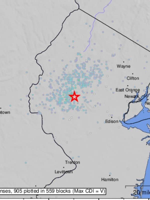
Many parts of New Jersey are under a coastal flood warning with an offshore storm and a full moon expected to fuel high tides, forecasters said.
The National Weather Service issued the coastal flood warning in Atlantic, Burlington, Cape May, Middlesex, Monmouth, and Ocean counties at 6 a.m. on Monday, Mar. 25. The NWS said the warning would be in effect until 2 p.m. on Tuesday, Mar. 26.
A storm out in the Atlantic Ocean will increase offshore wind speeds and make waves larger, according to the NWS. That will combine with Monday night's full moon to create "widespread tidal flooding."
The w…
Snow Squalls Smack NJ, Temps To Plummet (Video)
The first day of spring is behind us, but winter seems to be sticking around.
Snow and rain showers were possible Wednesday evening, March 20, with some snow squalls already having smacked the northernmost parts of New Jersey.
From a spotter in High Point earlier, around 4 PM, where 1 to 2" of snow fell quickly in northwest Sussex County NJ, as... Posted by US National Weather Service Philadelphia/Mount Holly on Wednesday, March 20, 2024
According to the National Weather Service, flurries were possible in Warren, Sussex, and Morris counties in New Jersey; and across the Lehigh Vall…
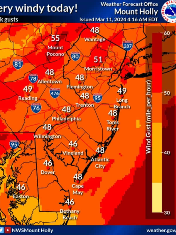
600 Without Power In Mercer County, 50 MPH Winds Will Last All Day
Wind gusts nearing 50 miles per hour left thousands of New Jersey residents without power Monday, March 11.
According to the National Weather Service, winds are expected to die down in the evening with a wind advisory in effect until 11 p.m.
Skies will be mostly cloudy with a high near 50.
As of 4:15 p.m., the following areas did not have power:
JCP&L:
Hunterdon County: 4,264 without power mostly in Bethlehem, Glen Gardner, Hampton, Hampton, High Bridge, Lebanon, Readington
Middlesex County: 8,359 without power mostly in Monroe Township
Morris County: 10,049 mostly in…
Snow, Hail Could Be Part Of Damaging Mid-Week Storm Headed To NJ, PA: Forecasters
Forecasters are tracking a gusty storm bringing rain and some snow to parts of New Jersey and Pennsylvania.
Rain is expected to begin across both states Tuesday evening, Feb. 27, and continue through Wednesday morning, Feb. 28, the National Weather Service says.
☔️ Multiple rounds of rain & storms will occur across central PA through Wednesday evening, Stay Weather Aware!
1⃣: Tues... Posted by US National Weather Service State College PA on Tuesday, February 27, 2024
While temperatures on Wednesday could reach a high of 60, a steep drop is expected in the evening to around 30, …
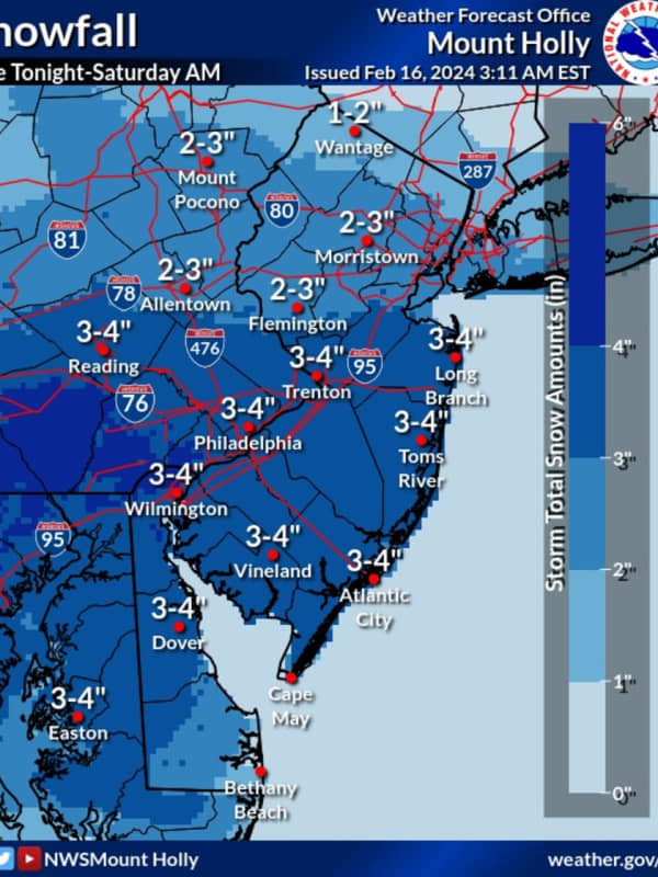
Forecasters Were Way Off: 8.5 Inches Of Now Fell In This Mercer County Town
Four inches of snow at most was expected in the second snow storm of the week in New Jersey and Pennsylvania.
But much more fell.
In the Friday, Feb. 16 and Saturday, Feb. 17 storm, up to 13 inches of snow fell in some towns across the region, according to the National Weather Service.
Here's who got the most snow, according to the National Weather Service:
ATLANTIC, NJ: Beuna Vista, 3.3 inches; Hammonton, 2.8 inches; Somers Point, 2.2 inches
BERKS, PA: Lyons, 12 inches; Fleetwood, 9 inches; Blandon, 8.5 inches
BERGEN, NJ: Westwood 3 inches; Fair Lawn 2.5 inches; River Vale 2 …
Coastal Flooding, Wind Expected From Pre-Valentine's Day Winter Storm On Jersey Shore
While many parts of the Jersey Shore won't see snow, a winter storm is expected to bring some issues right before Valentine's Day, forecasters said.
According to the National Weather Service, moderate coastal flooding is forecasted from Perth Amboy to Cape May on Tuesday, Feb. 13. Minor flooding coastal flooding is expected along the Delaware Bay and Delaware River.
Parts of Burlington, Cumberland, Monmouth, Ocean, and Salem counties are expected to get about an inch of snow. While inland Atlantic County could see some snow, the coast and Cape May County aren't forecasted to receive any acc…
Increased Snow Projections: Winter Weather Advisory Issued For Mercer County
The National Weather Service says parts of New Jersey and Pennsylvania could see more snow than what was initially predicted due to a shift in the storm track.
In an updating briefing published Monday, Feb. 12, the NWS said 12 to 18 inches of snow could fall in parts of Sussex County, NJ and the Pocono Mountains.
ALSO SEE: North Jersey School Closed, Delayed Ahead Of Major Winter Storm
The weather map shows between 8 and 12 inches expected in parts of Bergen, Morris, Passaic, Essex, Warren, Somerset and Hunterdon counties, where winter storm warnings have been issued. Winter weather a…
Coastal Flooding Possible Across South Jersey Despite Clear Skies This Week
Despite no rain or snow expected for the week ahead, forecasters are warning residents about the threat of coastal flooding across New Jersey.
The National Weather Service said South Jersey will have a threat of minor flooding through 7 p.m. on Thursday, Feb. 8. A coastal flood advisory was issued for Tuesday, Feb. 6 in Atlantic, Burlington, Camden, Cape May, Cumberland, Gloucester, Ocean, and Salem counties.
Minor flooding is forecasted during morning high tides in Atlantic City, Great Egg Harbor Bay at Ocean City, Cape May Harbor, and Barnegat Harbor.
"While the weather will remain …
Colder Air, Snow: Timing, Updates On New Winter Storm In NJ, PA
More seasonable weather is on the way this weekend, forecasters say.
Following days of spring-like temps, colder air more suitable for January days, along with a wintry mix, is headed to New Jersey and Pennsylvania in the next two days, according to AccuWeather and the National Weather Service.
Coastal low pressure will begin to bring mainly rain to the region tonight. Total rainfall is not expected to be all... Posted by US National Weather Service Philadelphia/Mount Holly on Saturday, January 27, 2024
"A pattern change featuring a return to colder air more typical of conditions f…
New Forecast: Increased Snowfall Totals Expected, Arctic Temps To Follow Northeast Storm
Newly-released forecast maps show parts of the region could see up to six inches of snow in the end-of-week storm.
Intermittent snow is expected to begin between 4 and 7 a.m. Friday, Jan. 19, with the heaviest amounts falling in the afternoon, the National Weather Service said.
Snow will fall at about 0.5 inches per hour and will taper by the evening, with temps in the upper 20s and low 30s, the NWS said.
SNOWFALL PREDICTIONS
The areas expected to get 4 to 6 inches are Trenton, Long Branch, Allentown, and Philadelphia. Reading, Vineland, Parsippany and Toms River are expected to get 3 to …